")
The distribution data of Central Asia desert oil and gas fields are in the form of vector data in ". SHP". Including the distribution of oil and gas fields and major urban settlements in the five Central Asian countries. The data is extracted and cut from modis-mcd12q product. The spatial resolution of the product is 500 m, and the time resolution is 1 year. IGBP global vegetation classification scheme is adopted as the classification standard. The scheme is divided into 17 land cover types, among which the urban data uses the construction and urban land in the scheme. The data can provide data support for the assessment and prevention of sandstorm disasters in Central Asia desert oil and gas fields and green town.
GAO Xin
")
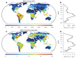
Nighttime light remote sensing has been an increasingly important proxy for human activities including socioeconomics and energy consumption. Defense Meteorological Satellite Program-Operational Linescan System from 1992 to 2013 and Suomi National Polar-Orbiting Partnership-Visible Infrared Imaging Radiometer Suite since 2012 are the most widely used datasets. Despite urgent needs for long-term products and pilot explorations in synthesizing them, the publicly available long-term products are limited. We propose a Night-Time Light convolutional Long Short-Term Memory (NTLSTM) network, and apply the network to produce annual Prolonged Artificial Nighttime-light DAtaset (PANDA) in China from 1984 to 2020. Model assessments between modelled and original images show that on average the Root Mean Squared-Error (RMSE) reaches 0.73, the coefficient of determination (R2) reaches 0.95, and the linear slope is 0.99 at pixel level, indicating a high confidential level of the data quality of the generated product. In urban areas, the modelled results can well capture temporal trends in newly built-up areas but slightly underestimate the intensity within old urban cores. Socioeconomic indicators (built-up areas, Gross Domestic Product, population) correlates better with the PANDA than with previous products in the literature, indicating its better potential in finding different controls of nighttime-light variances in different phases. Besides, the PANDA delineates different urban expansion types, outperforms other products in representing road networks, and provides potential nighttime-light sceneries in early years. PANDA provides the opportunity to better bridge the cooperation between human activity observations and socioeconomic or environmental fields
ZHANG Lixian, REN Zhehao, CHEN Bin, GONG Peng, FU Haohuan, XU Bing

1) Data content: this data set is the landslide disaster data of Sanjiang Basin in the southeast of Qinghai Tibet Plateau; 2) Data source and processing method: this data set was independently interpreted by Dai Fuchu of Beijing University of technology using Google Earth; This data file is finally formed by remote sensing interpretation - on-site verification - re interpretation - re verification and other methods after 7 systematic interpretation. More than 5000 landslides have been verified on site with high accuracy; 4) This data has broad application prospects for hydropower resources development, traffic engineering construction and geological disaster evaluation in the three river basins in the southeast of Qinghai Tibet Plateau.
DAI Fuchu
")
This vegetation water content data set is derived from the ground synchronous observation in the Luanhe River Basin soil moisture remote sensing experiment, including 55 sampled plots.The vegetation types involved in these sampled plots include grass, corn, potatoes, naked oats and carrots. The data measurement time is from September 13, 2018 to September 26, 2018.
ZHENG Xingming, JIANG Tao
")
As the roof of the world, the water tower of Asia and the third pole of the world, the Qinghai Tibet Plateau is an important ecological security barrier for China and even Asia. With the rapid development of social economy, human activities have increased significantly, and the impact on the ecological environment is growing. In this paper, eight factors including cultivated land, construction land, National Road, provincial road, railway, expressway, GDP and population density were selected as the threat factors, and the attributes of the threat factors were determined based on the expert scoring method to evaluate the habitat quality of the Qinghai Tibet Plateau, so as to obtain six data sets of the habitat quality of the agricultural and pastoral areas of the Qinghai Tibet Plateau in 1990, 1995, 2000, 2005, 2010 and 2015. The production of habitat quality data sets will help to explore the habitat quality of the Qinghai Tibet Plateau and provide effective support for the government to formulate sustainable development policies of the Qinghai Tibet Plateau.
LIU Shiliang, LIU Yixuan, SUN Yongxiu, LI Mingqi
")
This data is the hydrological data of kuzhan hydrological station in the middle reaches of the Xier river. The station is jointly built by Urumqi Institute of desert meteorology of China Meteorological Administration, Institute of water energy and ecology of Tajik National Academy of Sciences and Tajik hydrometeorological Bureau. The data can be used for scientific research such as water resources assessment and water conservancy projects in Central Asia. Data period: November 2, 2019 to December 5, 2020. Data elements: Hourly velocity (M / s), hourly water level (m) and hourly rainfall (m) Site location: 40 ° 17 ′ 38 ″ n, 69 ° 40 ′ 18 ″ e, 320m
ZHANG Na
")
This dataset includes year-on-year data on urban construction land changes in five countries in Central Asia (Kazakhstan, Kyrgyzstan, Tajikistan, Turkmenistan, and Uzbekistan) from 1985 to 2018. The data has a spatial resolution of 30m and a temporal resolution of one year. It is derived from the Global Artificial Impervious Area (GAIA) change data extracted from Landsat images from 1985 to 2018 (Gong Peng et al.). The researchers evaluated 7 sets of data every 5 years from 1985 to 2015. The average overall accuracy is over 90%, and it is the only urban construction land dataset spanning 30 years.
XU Xiaofan, TAN Minghong
The global land surface characteristic parameter (LAI) product was used with a spatial resolution of 5 km. The product uses generalized regression neural network method to retrieve Lai from AVHRR surface reflectance data. In this study, 12 issues of Lai data products from June to August of each year in five Central Asian countries, Mongolia and Northern China from 1981 to 2017 were downloaded from the national science and technology infrastructure platform National Earth System Science Data Center. These images are cropped by ArcGIS software, and the maximum value is calculated to obtain the spatiotemporal data set of the largest Lai. Among them, five Central Asian countries include Turkmenistan, Kyrgyzstan, Kazakhstan, Tajikistan and Uzbekistan; northern China refers to the area north of the Yangtze River in China.
ZHANG Na
")
The dataset of urban land and urbanization index on the Tibetan Plateau mainly includes the spatial distribution data of all urban land on the Tibetan Plateau (2019) and urbanization index of different scales (2018). The dataset of urban land was obtained by the visual interpretation of Google Earth images (2019), and the residential place and residential area data of "1:250000 national basic geographic database - 2015 edition". The dataset of urbanization index was based on the composite night light index (CNLI) at the regional, provincial, watershed, prefecture, and county scales calculated from the night light data of Luojia-1. Our dataset will support the study of optimizing the ecological security barrier system in the key urbanization areas of the Tibetan Plateau
HE Chunyang, LIU Zhifeng, Wang Yihang
")
The dataset is the land cover of Qing-Tibet Plateau in 2012. The data format is a TIFF file, spatial resolution is 300 meters, including crop land, grassland, forest land, urban land, and so on. The dataset offers a geographic fundation for studying the interaction between urbanization and ecological reservation of Qing-Tibet Plateau. This land cover data is a product of CCI-LC project conducted by European Space Agency. The coordinate reference system of the dataset is a geographic coordinate system based on the World Geodetic System 84 reference ellipsoid. There are 22 major classes of land covers. The data were generated using multiple satellite data sources, including MERIS FR/RR, AVHRR, SPOT-VGT, PROBA-V. Validation analysis shows the overall accuracy of the dataset is more than 70%, but it varies with locations and land cover types.
DU Yunyan
")
The dataset is the land cover of Qing-Tibet Plateau in 2011. The data format is a TIFF file, spatial resolution is 300 meters, including crop land, grassland, forest land, urban land, and so on. The dataset offers a geographic fundation for studying the interaction between urbanization and ecological reservation of Qing-Tibet Plateau. This land cover data is a product of CCI-LC project conducted by European Space Agency. The coordinate reference system of the dataset is a geographic coordinate system based on the World Geodetic System 84 reference ellipsoid. There are 22 major classes of land covers. The data were generated using multiple satellite data sources, including MERIS FR/RR, AVHRR, SPOT-VGT, PROBA-V. Validation analysis shows the overall accuracy of the dataset is more than 70%, but it varies with locations and land cover types.
DU Yunyan
")
Based on 2015 ESA global land cover data (ESA GlobCover, 300 m grid), combined with the tsinghua university global land cover data (FROM GLC, 30 m grid)、NASA MODIS global land cover data (MCD12Q1, 300 m grid)、the United States Geological Survey (USGS global land data (GFSAD30, 30 m)、Japanese global forest data (PALSAR/PALSAR - 2, 25 m),we build the LUC classification system in the Belt and Road’s region and the rest of the data transformation rules of the classification system.We also build the land cover classification confidence function and the rules of fusing land classification to finish the Integration and modification of land cover products and finally complet the land use data in the Belt and Road’s region V1.0(64 + 1 countries, 2015, 1 km x 1 km grid, the first level classification).
XU Erqi
")
The dataset is the land cover of Qing-Tibet Plateau in 2015. The data format is a TIFF file, spatial resolution is 300 meters, including crop land, grassland, forest land, urban land, and so on. The dataset offers a geographic fundation for studying the interaction between urbanization and ecological reservation of Qing-Tibet Plateau. This land cover data is a product of CCI-LC project conducted by European Space Agency. The coordinate reference system of the dataset is a geographic coordinate system based on the World Geodetic System 84 reference ellipsoid. There are 22 major classes of land covers. The data were generated using multiple satellite data sources, including MERIS FR/RR, AVHRR, SPOT-VGT, PROBA-V. Validation analysis shows the overall accuracy of the dataset is more than 70%, but it varies with locations and land cover types.
DU Yunyan
")
Land use and land cover map of Amu river Basin includes four periods: 1990, 2000, 2010 and 2015. The data produced by the key laboratory of remote sensing and GIS, Xinjiang institute of ecology and geography, Chinese Academy of Sciences, the spatial resolution of data is 30 m. Data production Supported by the Strategic Priority Research Program of Chinese Academy of Sciences, Grant No. XDA20030101. The land use map of Amu river basin is based on Landsat TM and ETM image data in 1990, 2000, 2010 and 2015. Firstly, with the help of eCognition software, the object-oriented classification is carried out. Secondly, the classification results are checked and corrected manually. Finally, the data validation methods are field validation and high-precision image validation.
XU Wenqiang
")
The gridded desertification risk data in Central-Western Asia was calculated based on the environmentally sensitive area index (ESAI) methodology. The ESAI approach incorporates soil, vegetation, climate and management quality and is one of the most widely used approaches for monitoring desertification risk. Based on the ESAI framework, fourteen indicators were chosen to consider four quality domains. Each quality index was calculated from several indicator parameters. The value of each parameter was categorized into several classes, the thresholds of which were determined according to previous studies. Then, sensitivity scores between 1 (lowest sensitivity) and 2 (highest sensitivity) were assigned to each class based on the importance of the class’ role in land sensitivity to desertification and the relationships of each class to the onset of the desertification process or irreversible degradation. A more comprehensive description of how the indicators are related to desertification risk and scores is provided in the studies of Kosmas (Kosmas et al., 2013; Kosmas et al., 1999). The main indicator datasets were acquired from the Harmonized World Soil Database of the Food and Agriculture Organization, Climate Change Initiative (CCI) land cover of the European Space Agency and NOAA’s Advanced Very High Resolution Radiometer (AVHRR) data. The raster datasets of all parameters were resampled to 1km and temporally assembled to the yearly values. Despite the difficulty of validating a composite index, two indirect validations of desertification risk were conducted according to the spatial and temporal comparison of ESAI values, including a quantitative analysis of the relationship between the ESAI and land use change between sparse vegetation and grasslands and a quantitative analysis of the relationship between the ESAI and net primary production (NPP). The verification results indicated that the desertification risk data is reliable in Central-Western Asia.
XU Wenqiang
")
The data set analyzes the spatial and temporal distribution, impact and loss of typical global flood disasters from 2018 to 2019. In 2018, there were 109 flood disasters in the world, with a death toll of 1995. The total number of people affected was 12.62 million. The direct economic loss was about 4.5 billion US dollars, which was at a low level in the past 30 years. The number of global flood incidents in 2018 was higher in the first half of the year than in the second half of the year, and the frequency of occurrence was higher from May to July. Therefore, based on three typical disaster events such as the hurricane flood in Florence in the United States in 2018, the flooding of the Niger River in Nigeria in 2018, and the Shouguang flood in Shandong Province in 2018, the disaster background, hazard factors, and disaster situation were analyzed. .
JIANG Zijie, JIANG Weiguo, WU Jianjun, ZHOU Hongmin
")
This data set contains 2018 global forest fire case data for the whole year and 2019, including the forest fire in California in November 2018, the forest fire in Attica, Greece in July 2018, and the forest fire in Shanxi Province in March 2019. Case data. Specific data include: fire intensity data of the monitoring range and data of vegetation index changes before and after the disaster. The data set is mainly used to describe the occurrence, development, impact and recovery of major global forest fire events in the first half of 2018-2019. The data mainly comes from NASA official website and EM-DAT database, it was processed by statistical and spatial analysis methods using EXCEL and ArcGIS tools. The data source is reliable, the processing method is scientific and rigorous, and it can be effectively applied to global (forest fire) disaster case analysis research.
YANG Yuqing, GONG Adu, WU Jianjun, ZHOU Hongmin
Contact Support
Links
National Tibetan Plateau Data CenterFollow Us

A Big Earth Data Platform for Three Poles © 2018-2020 No.05000491 | All Rights Reserved
|  No.11010502040845
Tech Support: westdc.cn